


Our monthly risk reduction series explores how geofencing technology can help mitigate specific safety incidents in the railway industry, offering practical insights and strategies for creating safer and more efficient work environments. In this edition, we explore how geofencing can help reduce the risk of incidents involving vehicles on worksites.
The challenge with managing vehicle movements on railway worksites
On-track plant (OTP), on-track machinery (OTM), and Engineering Train movements are an essential part of many railway projects, from transporting materials to supporting track renewals and maintenance. However, they can introduce a significant source of risk to those working onsite, and also have the potential to cause costly damage all leading to time consuming investigations if not properly managed.
With multiple vehicles often operating in close proximity to one another as well as workers, there is the potential for incidents such as collisions, points run throughs, working outside of agreed areas or in the worst case encroachment onto open lines. Traditional methods such as verbal briefings, signage, or relying on visual supervision can be limiting, especially on complex sites or where visibility is poor.
Without accurate, real-time visibility of where vehicles are and their movements, even a small mistake can quickly escalate into a safety incident.
Reducing the risk of unsafe vehicle movements
Geofencing technology helps mitigate the risk of incidents involving vehicles by providing Engineering Supervisors (ES) the tools to monitor vehicle movements using an online Dashboard.
1. Geofences are digitally mapped on the Dashboard for designated safe working areas
2. Vehicles are fitted with positioning devices, enabling their real-time location to be monitored.
3. This creates a ‘digital twin’ of the worksite, giving the ES a live view of all vehicles and their movements
4. If a vehicle approaches a hazardous area or leaves its assigned safe zone, both the operator and ES receive instant alerts, allowing for immediate corrective action.
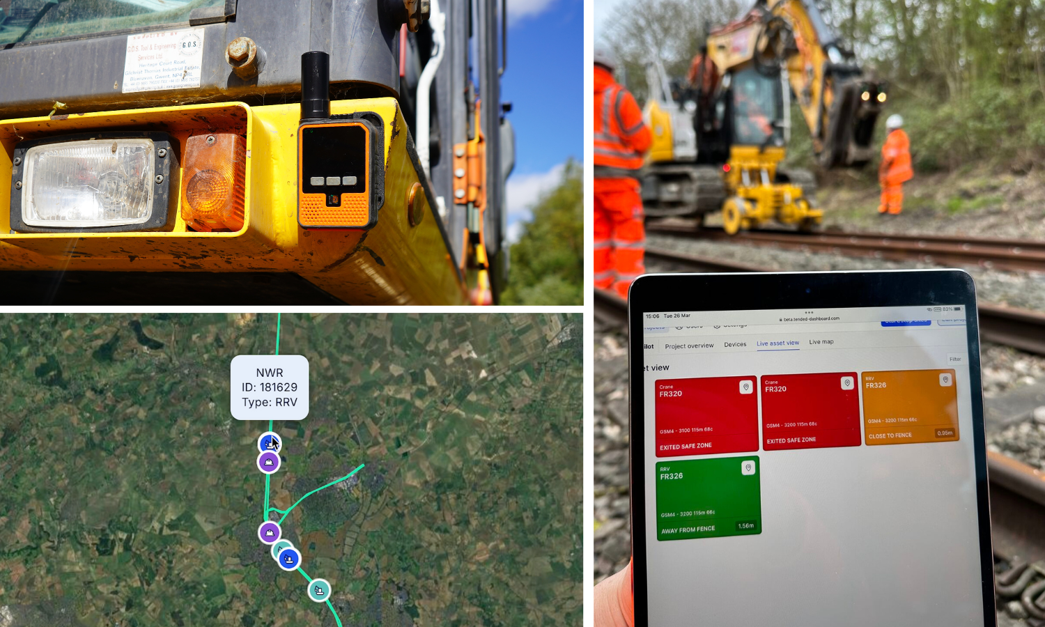
Enhanced visibility with the RAG view
A RAG (Red, Amber, Green) view on the Dashboard also provides an intuitive, at-a-glance overview of all onsite vehicle movements, making it easier for teams to identify unsafe events before they escalate.
- Red indicates a potential safety issue, such as a vehicle speeding, exiting the safe zone, or approaching a set of points.
- Amber flags early warnings, for example, a vehicle nearing the edge of a worksite boundary.
- Green confirms that vehicles are operating safely within the designated safe zone.
Each alert can be clicked to reveal the live location and details of the vehicle on the Dashboard, allowing quick and informed decision making. This helps the ES maintain visibility and control across even the largest and most complex worksites, reducing the likelihood of incidents and delays.
This approach supports safer, more efficient project delivery by helping the ES to quickly identify unsafe behaviour and take action:
- Vehicles speeding
- Assets approaching the zone boundary
- Vehicles approaching points
- Vehicles or assets exiting the safe zone
By applying geofencing technology to vehicle management, the risk of vehicle-related incidents can be greatly reduced. With enhanced visibility and real-time alerts, geofencing helps empower organisations to maintain control, improve situational awareness, and mitigate onsite risk .